
No time for a one thousand mile hike? Here are a few stops along the trail that will allow you to experience its beauty in your spare time.
The Ice Age National Scenic Trail loops 1,000 miles through Wisconsin, beginning and ending at beautiful state parks: Interstate Park on the St. Croix River north of the Twin Cities and Potawatomi State Park on the shore of Green Bay in Door County.
It follows the edge of the Wisconsin Glaciation, swooping from the Northern Highland forest south to nearly the Illinois border, taking in iconic state landscapes that include waterfalls, the sand country, oak savannas, the Kettle Moraine, the Baraboo Range, and the Niagara escarpment that makes up the spine of Door County.
In central Wisconsin, the trail splits into two loops, taking in both the boyhood home of John Muir and the Wisconsin Dells and Baraboo Range. While through-hiking the trail is becoming more popular, most of us only have time for weekend jaunts. Here are a few good ones.
Lapham Peak Puts You High Above Kettle Moraine
The popular Lapham Peak hike in Waukesha County will take you to the top of a 1,223-feet kame, a glacier structure shaped like a huge gumdrop. You can climb still higher—up a 45 foot tower—for even better views of Holy Hill, downtown Milwaukee, and the Kettle Moraine State Forest.
This is also the location of Wisconsin’s original National Weather Service reporting station.
Lapham Peak is named for Milwaukee citizen scientist Increase Lapham, who is known as the father of the National Weather Service. This trail section connects to hiking, biking and cross country ski trails that are part of the state forest.
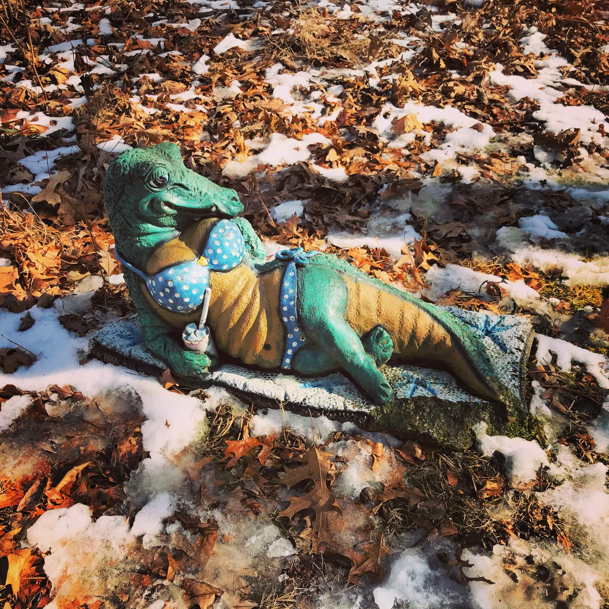
Table Bluff Hike Takes You From Goat Prairie to Stream
The Table Bluff hike, which is two and a half miles from parking area to parking area, begins high on a restored prairie off Table Bluff Road near Cross Plains in Dane County.
It dips up and down, traversing the unglaciated area ending on a bluff with views across the Black Earth Creek Valley to Blue Mounds. The middle section is opened by the Swamplovers Preserve, and is closed during the gun deer season.
Kids love to look for the Swamplovers alligator statue near the southern end of the trail segment.
John Muir’s Boyhood Home Offers a Pleasant Walk
Before naturalist John Muir hiked 1,000 miles to the Gulf of Mexico or did his famous hike from San Francisco to Yosemite, he started hiking the hills of Marquette County near his family’s farm. The Scottish Muirs homesteaded on the shores of Ennis Lake from 1849-56.
This 1.8-mile segment loops around Ennis Lake, passing meadows of wild flowers and a fen. From the top of a rise in Muke Park State Natural area, you can see the 30-acre kettle lake.
Bohn Lake Was Carved by a Glacial River’s Channel Tunnel
As the glaciers began to melt, a honeycomb of rivers flowed through the ice.
Bohn Lake, along with Fish and Crooked lakes in nearby Hancock, were carved by one river, then filled by melting blocks of ice left behind when the glacier retreated.
Parking on Highway B will begin the hike with a descent to this uninhabited lake. You can make the hike a loop by returning on town roads and via a handicapped-accessible trail from the second parking lot.
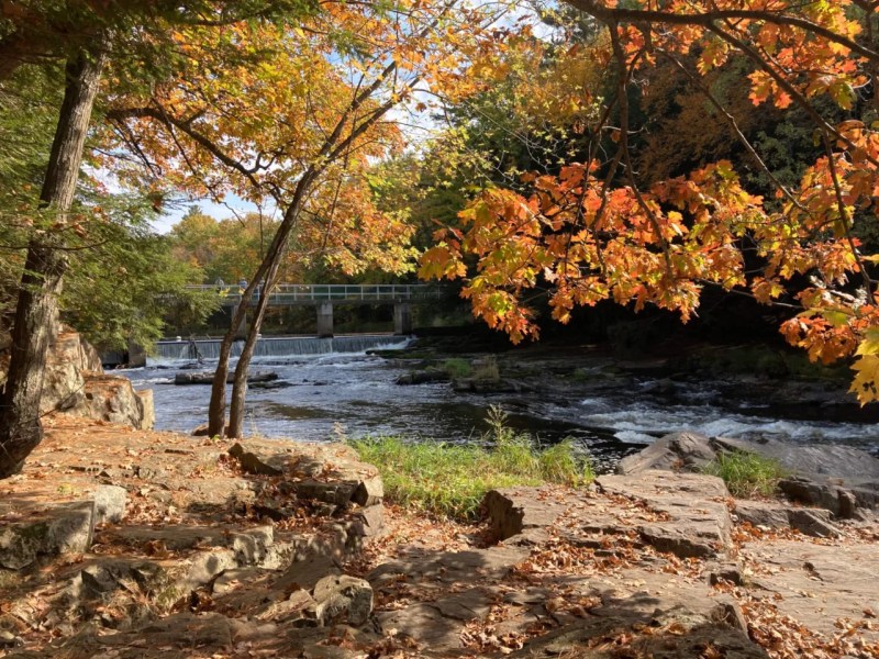
Dells of the Eau Claire: Spectacular Scenery on a River’s Edge Hike
One of the most spectacular sections of the Ice Age Trail follows the Eau Claire River through a Marathon County Park. The Dells of the Eau Claire segment has views of water cascading through a gorge cut by the meltwater of the Green Bay Lobe of the glacier.
You’ll also cross 30 feet above the river on the Dells High Bridge built by Civilian Conservation Corps workers during the 1930s.
Grandfather Falls Trail Follows an Indian Portage Route
The hike along Grandfather Falls in Lincoln County takes you along a cascading waterfall where the Wisconsin River was once called Grandfather Bull falls by the Indigenous people. They established a portage trail around the falls that was later used by the voyageurs. Today the Ice Age Trail follows the same path. Park at Camp New Wood County Park and head upstream along the river.