“Nowhere is that more prevalent than our corner of the state,” says Wisconsin’s Department of Revenue secretary.
Political redistricting is supposed to keep boundaries as compact as possible, and to make sure people with common interests are together. Doing so means citizens generally aren’t being represented by elected officials who live in other municipalities or counties, or have completely different priorities from the people they represent.
But when Wisconsin Republicans in 2011 approved new political boundaries, they threw that guidance out the window by creating the most gerrymandered maps the state, if not the nation, has ever seen. Towns and counties were split between two or more Assembly or Senate districts. Voters were carved from their usual districts and thrown in with residents of cities with little common interest, all to serve the purpose of delivering Republicans near-unbreakable majorities in the Assembly and Senate.
“Nowhere is that more prevalent than our corner of the state,” said state Department of Revenue Secretary Peter Barca, a Kenosha County resident and former Congressman and state representative.
Barca was one of about a dozen 1st Congressional District residents who spoke Thursday night at a meeting of the People’s Maps Commission, the nonpartisan board created by Gov. Tony Evers ahead of this year’s decennial redistricting. The commission is tasked with drawing maps that do not give Republicans or Democrats a baked-in advantage.
In the 1st Congressional District, which spans a swath of southeastern Wisconsin including Kenosha, Racine, and Janesville, the Assembly and Senate district borders set in 2011 criss-cross municipalities and counties with abandon. The pattern is particularly seen in Racine and Kenosha counties.
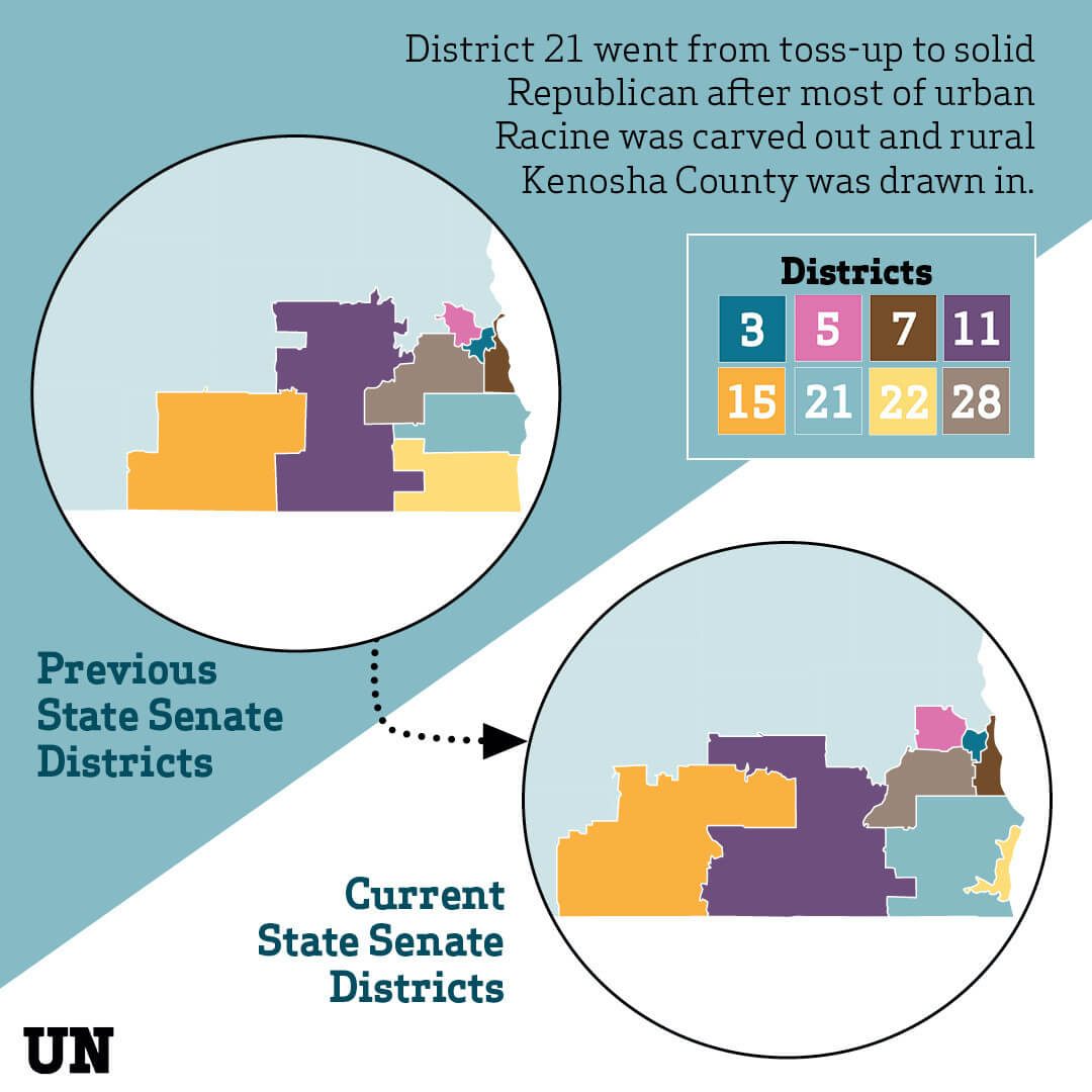
In the 2000s, Racine and Kenosha counties had their own state senators. The district encompassing most of Kenosha County was consistently Democratic, while the Racine County district was incredibly competitive.
But since 2011, the Racine County district has excluded most of the Democratic city of Racine, except for a small part of the city that includes the home of Sen. Van Wanggaard (R-Racine). The district now includes almost all of the more Republican, rural areas of Racine and Kenosha counties, making it a practically guaranteed win for Republican candidates.
Wanggaard’s district so drastically changed in the redistricting that it was a focal point of a 2018 Rolling Stone article on gerrymandering.
Meanwhile, the Kenosha County district was morphed to include the cities of Racine and Kenosha, making the area a lock for Democrats.
The net result: Democrats are packed into a district they already consistently won, while Republicans are packed into a formerly competitive district that now gives Democrats almost no chance to win.
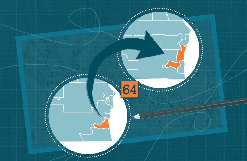
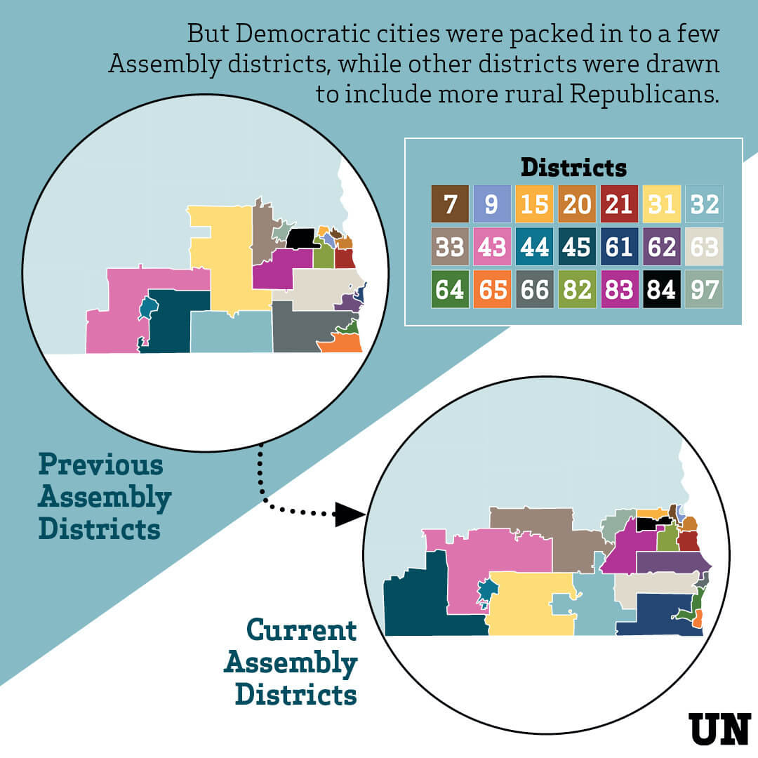
The same practice of splitting up communities of interest is seen in the area’s Assembly districts. John Scott, a retired teacher from Mount Pleasant in Racine County, lives in the 64th Assembly District, which Barca referred to as a “Nike swoosh.” It runs from the south side of Racine through Mount Pleasant, Somers, and the north side of Kenosha before “swooshing” west about seven miles.
“This is not voter equality, and this is not democracy,” Scott said last week during a presentation on partisan gerrymandering in the state’s 1st Congressional District hosted by the Wisconsin Fair Maps Coalition in advance of the People’s Maps Commission’s meeting. Scott spoke again Thursday night to advocate for an end to gerrymandering.
When communities are split in this way, Barca said, elected officials cannot adequately represent their constituents because the cities—especially similar, nearby communities like Racine and Kenosha—might have competing interests.
Wausau Mayor Katie Rosenberg, who lives in the 7th Congressional District, also testified Thursday night before the commission to speak against gerrymandering. Marathon County, which contains Wausau, is split between five Assembly districts and three state Senate districts.
Rosenberg said this has allowed state representatives and senators to ignore the needs of her city because Wausau and Marathon County voters are diluted across so many districts.
“Legislators who represent our city don’t have to talk to us,” Rosenberg said. Despite being elected mayor of Wausau almost a year ago, Rosenberg said she has never even spoken to her state Assembly legislator, Rep. Pat Snyder (R-Schofield).
The People’s Maps Commission has been meeting since last October. It has two public hearings left. The next, focused on the 6th Congressional District, which covers east-central Wisconsin is scheduled for Feb. 25. The final hearing, scheduled for March 11, will focus on the 2nd Congressional District in south-central Wisconsin.
Residents of any district are allowed to make public comments at the meetings.
After its hearings are completed, the People’s Maps Commission will get to work drawing fair maps. The Republican-led Legislature will almost certainly ignore the maps and pass their own gerrymandered versions, but Evers can veto any maps he deems too partisan. The matter would then go to the courts.