
Photo courtesy of Getty Images/Unsplash.
Taking the long way has its benefits—including the breathtaking views you’ll find on Wisconsin’s seven scenic byways.
Sometimes, it’s best to take the road less traveled—especially when you’re driving through Wisconsin. While the state is filled with plenty of interstate highways and expressways, there’s plenty of joy to be taken from traversing its byways as well.
Byways are roads or highways that are noted for being exceptionally scenic or containing cultural or historic significance. Wisconsin is home to seven of these roads, which make for great road trips. From a byway that circles nearly all of Door County to byways that offer stunning riverside views, there are plenty of unforgettable drives to be taken throughout the state.
Next time you’re driving through Wisconsin, avoid the state’s major highways and expressways by taking the more majestic route and traveling along Wisconsin’s seven scenic byways.
1. Door County Coastal Byway
Starting point: Sturgeon Bay
Ending point: Sturgeon Bay
Length: 66 miles
Each year, more than two million people travel to Door County, a peninsula in Wisconsin located between Green Bay and Lake Michigan. The county is well known for its lighthouses, beautiful fall foliage, and delicious cherries, but it’s also worth a visit to check out the Door County Coastal Byway, a 66-mile byway that circles throughout the county.
Unlike many other byways, the Door County Coastal Byway is a loop circling most of the Door County peninsula. It starts and ends in Sturgeon Bay, a city with a population of more than 9,000 residents and the county seat of Door County. The byway passes through many of the county’s most charming towns, including Ephraim, where byway travelers can stop by Anderson Dock, a much-graffitied dock that sits along Green Bay.
The byway also passes through Sister Bay, one of the county’s most-touristed hotspots. While there’s most likely always a wait, it’s worth checking out Al Johnson’s Swedish Restaurant, a Door County restaurant where you can order a stack of Swedish pancakes accompanied by lingonberries or Swedish meatballs. Don’t forget to check out the goats that frequently graze along the restaurant’s roof, as well.
2. Great River Road
Starting point: Prescott
Ending point: Kieler
Length: 250 miles
The Mississippi River runs for more than 2,300 miles and through 10 different states—starting in Minnesota and emptying into the Gulf of Mexico. While the Great River Road in Wisconsin doesn’t run the entire length of the famous river, it does span the entirety of the river’s run in Wisconsin—approximately 250 miles, with its northernmost point in Prescott and ending just north of the state’s border with both Illinois and Iowa, in Kieler.
As the Great River Road is extraordinarily lengthy, it’s understandable that there are many places that are worthy of a stop along the way. One of the most beautiful views along the scenic route can be found in La Crosse, at the top of Grandad’s Bluff, a 600-foot tall bluff that offers unbeatable views of the Mississippi River, as well as three different states: Wisconsin, Minnesota, and Iowa.
Fans of the “Little House on the Prairie” book series should make a stop in Pepin, one of the small villages along the road, as well as the birthplace of author Laura Ingalls Wilder. The village also houses the Laura Ingalls Wilder Museum & Birthplace, a museum that showcases what life was like back in the days when Wilder was living in Pepin, and also features a replica log cabin on the site where she was born.
Admission to the museum costs $10 for adults and $4 for students from kindergarten through high school. The museum also has a gift shop where fans can pick up an assortment of souvenirs, as well as copies of all of the author’s books.
3. Wisconsin Lake Superior Scenic Byway
Starting point: Barksdale
Ending point: Cloverland
Length: 70 miles
Wisconsin is surrounded by two of the five Great Lakes: Lake Michigan makes up the state’s eastern border, and in Wisconsin’s northernmost reaches, it shares 325 miles of shoreline with Lake Superior. Part of that shoreline is along the Wisconsin Lake Superior Scenic Byway, which runs along Wisconsin State Highway 13.
Stopping in Bayfield, one of the main cities along the byway, is highly recommended for travelers. Take a ferry out to Madeline Island, or enjoy time spent in the city. If visitors are up for a scare (and a history lesson), they can take the Bayfield Ghost Walk, a daily tour that leaves at 7:30 p.m. and costs $25 per person. Tourgoers can learn about apparitions that are rumored to have appeared at the Bayfield Library, as well as paranormal encounters at some of the small city’s charming bed-and-breakfasts.
While the byway travels along the side of Lake Superior, visitors would be remiss if they traveled it without actually exploring the lake themselves. One of the best ways to do that is by traveling out to the Apostle Islands National National Lakeshore, which comprises 21 islands near Bayfield. The lakeshore is open year-round—in the summer, it’s an ideal spot to kayak, and in the winter, travelers can explore the ice caves along the shoreline.
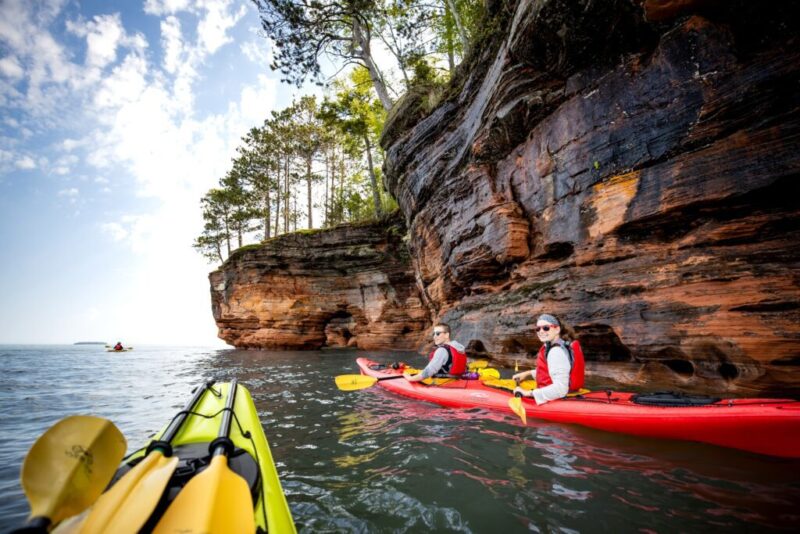
Photo courtesy of Bayfield County Tourism.
4. Great Divide Highway
Starting point: Glidden
Ending point: Hayward
Length: 29 miles
The Chequamegon-Nicolet National Forest is one of the most scenic spots in Wisconsin, so it makes sense that not just one but three different scenic byways in the state pass through it, including the Great Divide Highway. The 29-mile stretch of road travels along State Highway 77 between Glidden and Hayward, passing through the Chequamegon-Nicolet National Forest.
While there are plenty of things to do along the trail during the warmer months, the fun doesn’t stop during the winter. The Chequamegon-Nicolet National Forest has hundreds of miles of renowned snowmobile trails, including several that are maintained by the Clam Lake Forest Riders, based out of Clam Lake, a census-designated place along the scenic byway. There are also many miles of cross-country skiing and snowshoeing trails.
Fans of fishing can also stop by any of the lakes dotted along the scenic byway, including both Upper and Lower Clam Lake, and they can also stop at the Freshwater Fishing Hall of Fame in Hayward, a city that serves as the westernmost point along the Great Divide Highway. The Hall of Fame is best known for its 143-foot-long muskie sculpture that greets visitors as they pull into the museum and is the largest muskie sculpture in the world.
5. Lower Wisconsin River Road
Starting point: Lodi
Ending point: Prairie du Chien
Length: 100 miles
In Wisconsin, the state’s big river is the Mississippi River, which spans much of the state’s western border. But it’s far from the only river of note throughout the state. There’s also the Wisconsin River and the Lower Wisconsin River Road, which follows along its course for 100 miles.
The byway is the state’s Scenic Highway 60, which travels throughout southwestern Wisconsin’s stunning Driftless Area. This region in the Midwest was never covered by ice during the last Ice Age and is known for its picturesque ravines and bluffs.
An ideal way to explore the area is by just admiring its scenic views, which can be done by pulling over at one of the many parks or natural areas along the byway, including the Ferry Bluff State Natural Area. Ferry Bluff sits more than 300 feet above the Wisconsin River, offering unbeatable views of the river, especially during the fall, when visitors can take in the fall foliage and possibly even spot a bald eagle, which is known to roost in the area.
If you’re not the outdoorsy type, head indoors instead. Just off of the byway is Taliesin, a historic property just south of the Village of Spring Green with an estate owned by famed architect Frank Lloyd Wright. Several tours of the home are available daily, including an estate tour that covers the entirety of the state and is four hours long, as well as a shorter tour that solely covers the highlights of the estate and is just over two hours long.

Photo courtesy of Joshua Mayer/CC BY-SA 2.0.
6. Heritage Drive
Starting point: Eagle River
Ending point: Three Lakes
Length: 15 miles
Sure, it doesn’t take too long to drive the 15-mile length of Heritage Drive, but to make the most of the scenic byway, which travels through the Chequamegon-Nicolet National Forest, it’s best to take two to three hours. The route primarily follows along Military Road and was named for its former use—before it was a scenic byway, the road was initially built to transport guns, ammunition, and troops north in case of an English invasion that came through Canada.
Now that its primary use is for scenic driving, an ideal way to enjoy traveling the short byway is, well, to get off of the byway in a sense. The byway passes through the scenic forest that offers great hiking, so pull over and explore the area on foot in addition to touring it by car. The forest terrain is relatively flat, making it a great place to go for an easy hike, especially through Cathedral Pines—a 40-acre grove of white pine, hemlock, and red pine.
If you’re traveling the route with kids, make sure to pull over in Eagle River, the northernmost city along the byway, and visit the Northwoods Children’s Museum. The museum, which has been entertaining kids in northern Wisconsin since 1998, has more than 25 different exhibits, including its original grocery store exhibit, where kids can learn about healthy eating and cash handling.
7. Nicolet-Wolf River Scenic Byway
Starting point: Nelma
Ending point: Langlade
Length: 145 miles
In fact, if you look up the Nicolet-Wolf River Scenic Byway byway on a map, the northern Wisconsin byway would look like a pair of glasses. Made up of two loops, which are connected by a stretch of road, the Nicolet-Wolf River Scenic Byway takes travelers through some of the more scenic backroads in the state’s north. The route, which was designated a scenic byway in 2017, is 145 miles long and travels through four of Wisconsin’s counties: Forest, Langlade, Oneida, and Vilas.
If you want your tour of the Nicolet-Wolf River Scenic Byway to include a world record-setting sight and one of the state’s most offbeat roadside attractions, stop by the World’s Largest Soup Kettle in Laona. While it’s no longer used for serving soup, the kettle used to serve hundreds of people free soup if they showed up with their own bowl. The town of Laona still keeps up the free soup tradition at an annual community soup event.
During the warmer months, make sure to include a stop at the Bear Paw Outdoor Center, located just south of the byway’s southernmost town of Langlade. The adventure center, which is located in White Lake, is a great place to hit the trails on a mountain bike or rent a kayak to go along the Wolf River. The adventure center is open from May through October.
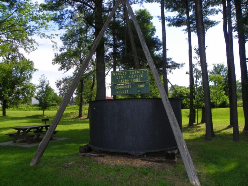
Photo courtesy of J. Stephen Conn/CC BY-NC 2.0.
This article first appeared on Good Info News Wire and is republished here under a Creative Commons license.
Milwaukee tourist traps that are worth the hype
Planning a weekend visit to Milwaukee? From restaurants and bars to museums and greenhouses, here’s a list of six local “tourist traps” that are...
The best places to eat, drink, and explore in Green Bay
Are you looking for the best places to eat, drink, explore, and score some delicious cheese to fully experience the magic of Green Bay? Look no...
9 activities that belong on every Wiconsinsite’s winter bucket list
Add these 9 Wisconsin adventures to your bucket list for a winter full of fun. Winter in Wisconsin might be chilly, but it’s also a magical time of...

Where to take a horse-drawn sleigh ride in Wisconsin
Get ready to go dashing through the snow this winter with a horse-drawn sleigh ride at one of these local Wisconsin locations. If you’re in the mood...


